 Follow
History of Kinsalebeg
Placenames & Old Names
Introduction
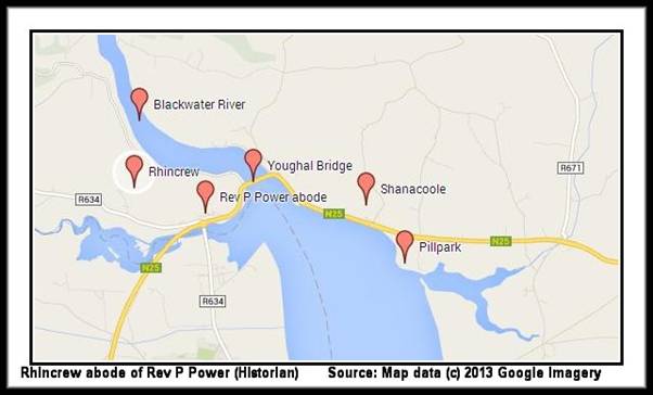
The following list of placenames of Kinsalebeg and nearby areas is primarily extracted from details in a publication The Placenames of the Decies1 written by Rev. Canon Power in 1907 and later modified by Alfred O’Rahilly of UCC in 1952. Canon Power was born at Callaghane near Waterford city and had a great interest in archaeology, local history, place names, ecclesiastical antiquities etc and published extensively in all those areas. He was appointed Professor of Archaeology at UCC and during the period he was in UCC he lived in Rhincrew in Waterford on the borders of Cork. Apparently he said that it was the closest he could get to Cork whilst still living in Waterford. The cottage he lived in is located up the hill on the right hand side after you have crossed Youghal Bridge and head towards the stone bridge turnoff which is the Cork boundary. It is sometimes forgotten that the whole of the Blackwater River including Youghal Bridge is in County Waterford from the bridge itself until you get close to Fermoy – it unfortunately means that we also have to take ownership of more than a few villains who lived on both banks of this river over the centuries. The placename information in the following chapter was written primarily in 1907 and earlier and was based on information and recollections of that time. The parishes associated with particular townlands have often changed in historical records and census records over the years so we have included townland information from parishes other than Kinsalebeg in this chapter. As an example townlands are in the parish of Kinsalebeg in one period and in Clashmore or Grange or Ardmore in another period and vice versa. In Canon Power’s records for example Pillpark, Shanacoole are in Clashmore parish, Ballyheeny is in Kinsalebeg, Garranspick is in Ardmore parish etc.
Many of the placenames in the parishes below are not familiar to parishioners any longer in these areas but we are inserting all placenames as recorded by Canon Power in 1907. We have also included later in the chapter townland names painstakingly pulled together by the Placenames Branch of the Department of Arts, Heritage and the Gaeltacht2 and we acknowledge their permission to use this information here. The relevance of this information is that it gives variations on the names of particular townlands of Kinsalebeg over the centuries – these could be actual name changes, misspellings or how the townlands were pronounced locally in Irish or English. The remainder of this overview of placenames and variations in townland names is extracted from the publications referenced above. We have no responsibility for the accuracy of the information and are including it here for reference only. It may act as a start point for putting together a more detailed list of local names for places, fields, houses, events etc.
![]()
Placenames of Kinsalebeg Parish
The following townland descriptions are directly from Rev. P. Power’s The Placenames of the Decies1:
THIS Parish (Ceann tSáile Beag - “Head of the Tide (or ‘Salt Water’ or ‘Brine’)” is so called from its position at the mouth of the bay. Its qualification, Beag, distinguishes it from Kinsale, Co. Cork. The parish yields some interesting cliff names and a few ecclesiastical names of importance. For an account of the ancient church which stood on the modern townland of Prospect Hall see Waterford Archaeological Journal, Vol. IV., pp.200, etc.
Townlands of Kinsalebeg:
BALLYHEENY: On this townland is a small ruined castle of the Desmonds, referred to in Castlehaven’s Memoirs, &c. Area, 278 acres. [Note – sometimes in Clashmore parish].
Sub denominations (S.D.):
(a) Poll an Tairbh- “Drowning Hole of the Bull.”
BALLYSALLAGH: Baile Saileach – “Willow Abounding Homestead.” Area, 376 acres. “Ballysallagh” (Inq. Jas. I.).
Sub denominations (S.D.):
(1) Inland:
(a) An Sruth – “The Stream.”
(b) Béal Abha – “River Mouth”; a name frequently applied to debouchure of a stream into the sea; it is popularly applied here to the strand of Whiting Bay and the district inland thereto adjoining; the notion is locally entertained that the Blackwater formerly fell into the sea at this place.
[Note: It is now well established, as distinct from a “local notion”, that the Blackwater river entered the sea at Whiting Bay rather than Youghal before 830 AD]
(c) Bun an Bhóthair – “End of the Road.”
(2) Coastwise:
(d) Whiting Bay (Ordnance Map); not Irish. The fish whiting = Faoítín, in local Irish.
(e) An Charraigín – “The Little Rock.”
(f) Cloch Liath – “Grey Rock.”
(g) Carraig Dhubh – “Black Rock.”
(h) Faill Bhuí – “Yellow Cliff.”
(i) Gaibhlín na Leathóg– “Sea Inlet of the Plaice.”
D’LOUGHTANE: Lochtán – “An Eminence.” Cpr. An Lochtaig, and Cnoc Lochta. Dr. O’Foley says that the proper word is Dlochtán- “A Strainer,” derived from wattles or palisade erected at mouth of tributary stream. Indenture of Sale (1851 Duke of Devonshire to Allen, for reclamation purposes) recites “the slobland of D’Loughtane between high and low watermark” (106a, 31r. 35p.) and “that other piece of slob, Crawnpaunamann, (Crampán na mBan) -1a. 2r. 20p., bounded on the north by Blackwater and E. and S. by woodland of D’Loughtane and by a stream, &c.” Area, 471 acres. “D’Loghtane als Gloghtane” (Distr. Bk.).
Sub denominations (S.DD):
(a) Linn na Sagart– “Pool of the Priests”; from drowning here of some priests a couple of hundred years ago. This is the place known to English speakers as the “Broad of Clashmore.”
(b) Bán an Phúca – “The Pooka’s Field.”
(c) Poll an Mhadra – “The Dog’s (or ‘Wolf’s’) Cave.”
(d) Móinéar na Cille– “Meadow of the Early Church Site”; the site in question is on north side of the road which runs east and west to the river.
DRUMGALLANE: Drom Galláin– “Ridge of the Pillar Stone.” There were formerly here two tall pillar stones - one slender, the other rather thick and stunted. Permission to cut “cross timber” in his woods at Drumgallen for repairs to the “great house of Lestynane (Glistinane)” was granted by Sir Nicholas Walsh in 1641. Area (in two divisions), 387 acres.
Sub Denominations (S.D.):
(a) Tobar na Feirse (Feirste) - “Well of the Spindle,” by side of the next.
(b) Bóthar Dhéagláin – “St. Declan’s Road”; a section of the legendary “Track of St. Patrick’s Cow.”
(c) Cloch an Tairbh – “Rock of the Bull.”
GARRANASPICK: Garrán an Easpaig - “The Bishop’s Grove”; a detached portion of the parish. Area 184 acres. [Note: Normally part of Kinsalebeg so included here – actual entry under Ardmore heading and refers to Garranaspick as detached part of Ardmore].
GLEBE: Known locally by no Irish name. Area, 7 acres.
GLISTINANE: Glisteaneáin (Glas tSeanáin) - “Senan’s Streamlet.” Or “Senan’s Green Place”. Area, 167 acres. “Glestinan” (Inq. Jas. I.). “Listenane,” “Listynane” and “Listenan” (Egmont MSS. passim).
KILGABRIEL: Cill Giriam and Cill Gáibrial (now generally Cill Uilliam)” – “Giriam’s or Gabriel’s Church.” The name of this church founder does not occur in the martyrologies, at least in the form here given. Area, 601 acres. “Kilgabriell als Kilgereim” (Inq. Jas. I.). “Kilgabriel” (Egmont MSS.).
Sub denominations ( S.D):
(a) Páirc na Cille – “Field of the Early Church Site”; on south side of the townland.
(b) Cnoc na Daraíghe -“Hill of the Oakwood”; a sub-division.
(c) Cnoc Riabhach - “Grey Hill”; another - sub-division.
(d) Móin an Cheoigh - “Bog of the Mist” a small, well-known sub-division.
(e) Poll na gCat - “The (Wild) Cats’ Cave.”
KILMEEDY: Cill Míde – “Mide’s (or ‘My Ida’s’) Church.” Area (in two divisions), 322 acres. “Kilmydie” (Inq. Jas. I.).
(Ref: Egmont,MSS., Vol. II., p.139)
Sub denominations ( S.D.):
(a) Páirc na Cille – “Field of the Early Church Site”; on Kennedy’s farm.
KILMALOO: Cill Molua – “Molua’s (or ‘My Lua’s’) Church.” The church site is marked on the six-inch Ordnance sheet. Sir Philip Percival by deed of trust, dated April 1, 1640, assigned “Kilmalooes, Piltowne, Monoterris, Listenan and Knocknegeragh” to his son George [Note: Actual landowner was Sir Nicholas Walsh Junior so above transaction would have been transfer of lease]. Area (in two divisions), 558 acres.
Sub denominations (S.D):
(a) Clais Ghainimhe- “Trench of the Sand (Pit)”; a sub-division of about 200 acres, locally recognised as a separate townland.
(b) Cnuicín na mBuachaillí - “Little Hill of the Cowboys.”
(c) Geataí Chill Molua – “Kilmaloo (Turnpike) Gates.”
(d) Loch Mór - “Great Pond”; a small lake on the ridge summit, close to which stands a couple of ice- houses. It is possible that this was originally a prehistoric “dewpond.”
(e) Páircín an Leacht – “Little Field of the Monument.”
(f) Barra an Aird – “Summit of the Height (Ridge).”
(g) Áth na Caile – “The Girl’s Ford”; perhaps because a girl was drowned here.
(h) Gáirdín Phiarais – “Pierce’s Garden”; so named from Pierce Fitzgerald, the poet, who, according to local tradition, lived here for a period.
[Note: Poet Pierce Fitzgerald did live in Kilmaloo for a considerable period of his life and died there sometime after 1791].
(i) Bóithrín Loftus – “Loftus’ Little Road”; named after General Loftus, who marched this way with his troops to Wexford in 1798.
KNOCKBRACK: Cnoc Breac – “Speckled Hill.” Extensive slate quarries were worked here a century ago. Visitors to the Cork exhibition would remember the exhibit of Knockbrack slate (1902) shown there. William Beale advises Sir Philip Percivall (1641): “A company of rogues and wicked members challenge part of Knockbracke to be of the lands of Dromgallen.”. Area, 214 acres. [Note: The “rogues and wicked members” above is a reference to agents & employees of Sir Nicholas Walsh Junior of Pilltown].
Sub denominations ( S.D):
(a) Páirc an Strae - “Field of the Wandering (Stray).” There are certain fields in which people are said to get lost at night, and that from other than natural causes.
LACKENDARRA: Leacain Dara - “Oak Bearing Glen Slope.” Area 78 acres. “Lackindoraghe” (Inq. Jas. I.).
MONATRAY: Móin Oitreach – “Rough or Uneven Bogs.” O’Donovan makes it “Otter’s Bog.” Area (in three divisions), 661 acres. “Monetray” (Distr. Bk.). “Monothirie” (Inq. Jas. I.).
Sub denominations ( S.D):
I. Inland:
(a) An Caisleán – “The Castle”; a field.
II. Coastwise:
(b) Cuainín - “Little Cove.”
(c) Gleann Beag – “Little Glen.”
(d) Gaibhlín na mBollaí– “Creek of the Bowls.” The “Bowls” here are rounded water-worn stones.
(e) Cuainín Roibeáird - “Robert’s Cove.”
(f) Carraig na Pollóige - “Pollock Rock.”
(g) Faill an Chapaill - “The Horse’s Cliff.”
(h) Geal Trá - “Bright (White) Strand.”
(i) Gaibhlín hArtaigh - “Harty’s Sea Inlet.”
(j) Gheárd - “Yard.”
(k) Tobhar an Chuaille – “Well of the Pole.”
(l) Gaibhlín Glan - “Clean Sea Inlet.”
(m) Nead an Naoi – “The Babe’s Resting Place (Nest).”
(n) Carraig an Stolla - “Standing Rock.”
(o) Carraig Láir na Trá - “Middle Rock of the Strand.”
(p) Inse Uí Fhlaithbheartaigh – “O’Flaherty’s Island” (“Calasoe Bay”).
(q) Poll Bréan – “Stinking Hole.”
(r) Tráighín Bheag - “Little Strand” (tautologically).
(s) Poll na gCág - “Cave of the Choughs.” Cág is generally a jackdaw, but along this coast the name is applied to the chough.
[Note: See photo].
(t) Barra na Rinne – “The Headland Summit.”
(u) Béardí na Rinne(?); a rock, seldom uncovered even at low water.
(v) Casán an Mhadra - “The Dog’s Path.”
(w) Poll an Ghuail - “Coal Hole.”
(x) An Gaibhlín - “The Sea Inlet.”
[DL note: Also known as The Guileen].
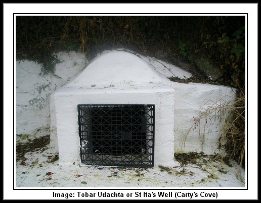
(y) Gaibhlín Buí - “Yellow Sea Inlet” (“Carty’s Cove”).
(z) Tobar Udhachta – “Well of Will (Penance)”; a holy well at which “rounds” are still regularly made.
[Note: Also known as St Ita’s Well – located in Carty’s Cove].
[Note: Decies Journal Vol 6-7 of 1978 has a reference to a field in Monatray called “An Caislean” and raises the question if this might indicate the presence of a castle here at some stage in the past.]
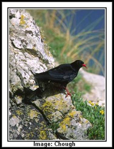
[Note: Choughs are a member of the crow family but without some of their bad habits. Choughs are about the size of a jackdaw with glossy black plumage, bright red legs and down curved beak. Choughs are often heard before they are seen. Choughs make for a truly engaging study species with their acrobatic antics often accompanied by sharp “chaaow” calls. (Info and image courtesy Birdwatch Ireland).]
MOORD: An Móird (An Magh Ard) - “The High Plain.” The height here is insignificant; it can only be called an elevation in relation to the slightly lower flat extending to the east. Area 62 acres. (Egmont MSS., Vol. I, p 114). (Egmont MSS ,Vol. I., p.135).
Sub denominations (S.D):
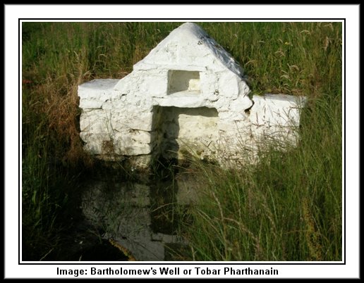
(a) St. Bartholomew’s Well (Ordnance Map), Tobar Phárthanáin. Idem. This is a well-known holy well at which a pattern is held and “rounds” made on August 24th.
MORTGAGE: An Morgáiste – “The Mortgaged Property.” Area, 146 acres.
NEWTOWN: Baile Nua. Idem. Area, 211 acres. “Newtowne” (Inq. Jas. I.).
PILLPARK: Páirc an Phoill - “Field of the Hole” (or “Pill”); Area 16 acres. A detached portion of the parish.
[Note: Pillpark sometimes included in Clashmore parish but included here as normally associated with Kinsalebeg and Pilltown. Original entry in Power Placenames is in Clashmore Parish and as above it is indicated that it is a detached portion of Clashmore].
PILLTOWN: Baile an Phoill - “Homestead of the River Inlet.” Here are the site and insignificant remains of a castle of the Walshs’. Area, 327 acres. “Pilltowne” (Inq. Jas. 1).
PROSPECT HALL: Fancy name of the usual meaningless character with no Irish form to correspond. Area, 358 acres.
Sub denominations (S.D):
(a) Ferry Point (Ordnance Map), Pointe an Chalaidh. Idem. In August, 1645, Castlehaven planted two batteries here to reduce the garrison of Youghal, and, though he failed in his immediate design, he succeeded in harassing the town and in sinking the “Duncannon” frigate.
(b) Cnoc an Phointe - “Point Hill.”
RATH: Ráth. Idem. Area, 419 acres. “Rath” (Inq. Jas. I.).
SPRINGFIELD: Fancy name of same style as Prospect Hall, above; no Irish form. Area (in two divisions), 108 acres.
TOBERAGOOLE: Tobar an Ghuail – “Well of the Coal”; the townland is better known locally as Carraig Uí Chais (“O’Cash’s Rock”). Area, 15 acres. “Tobberagoole” (Distr. Bk.).
![]()
Placenames of Clashmore Parish
Historically this is, after Ardmore, the most important parish of the Barony. Like almost all parishes attached to important pre-invasion foundations Clashmore is of large extent. Its nomenclature is of perhaps more than average interest; there are a dozen or more, very unusual names, and a few names which are of puzzling character. St. Cronin Mochua, a disciple of St. Cartage, founded the monastery and church of Clashmore, and here he and his household were murdered by pirates in or about 631. For further information see Journal of Waterford Archaeological Society, Vol. IV., pp.201, &c.
Townlands of Clashmore:
ABARTAGH: An Abartach - “The Peat (or Puddle) - Abounding Place.” Area 34 acres.
ARDSALLAGH: Ard Saileach - “Willow Height.” Area, 521 acres. “Ardsillaghe” (in deed of 1340 which, moreover, has references to “The Blackmoor of Rossenthenane” - evidently beside, or part of, Ardsallagh).
Sub denominations (S.D):
(a) Greenland (O.M.), a well-known sub-division, on which, owing to its position, the sun is said never, or but seldom, to shine.
(b) Rinn – “Point”; another well-known sub-division - probably an old townland.
(c) Tobar Bó Finne - “The White Cow’s Well.”
(d) Bóthar an Chalaidh - “Ferry Road.”
(e) Carn an Radhairc - “Cairn of the extensive View.”
(f) Garraí an Léir Fhoscaidh (?) - “Completely Sheltered Garden.”
(g) St. Bridget’s Well (Ordnance Map)), Tobar Bríde. Idem. Reputed holy well.
AUGHNACURRAVEIL: Áth na gCorra-Mhíol - “Ford of the Midges.'” Area, 287 acres.
Sub denominations (S.D):
(a) Tobar Bhriain - “Brian’s Well.”
(b) Poll na gCaorach - “(Washing) Hole of the Sheep”; this and the next are in the River Lickey.
(c) Poll na Muc - “Hole of the Pigs.”
(d) Cnoc an Leasa - Hill of the Lios”; this is a sub-division.
(e) Poll an Ghair - “Muck Hole”; a small lake.
(f) Clocha Garbha - “Rough Rocks”; ancient ford or crossing place of road (Rian Bó Phádraig), over the Lickey. This, no doubt, was the original Áth from which the townland derives its name and in which Baillin, a disciple of St. Patrick, was drowned.
BALLINAMULTINA: Baile na mBoiltíneach - “Homestead of the Boltons’.” A fair was held by patent at the village of Cross three times annually but, as it became a source of much dissipation and quarrelling, it was abolished about seventy years since. The Fair dates were: Easter Tuesday, September 8th and November 13th. Area 540 acres.
Sub divisions(S.D):
(a) Cross (Ordnance Map), Crois - “Cross roads.”
(b) Bán an Bheilín - “Field of the Little Aged Tree.”
(c) Sean Bhaile - - “Old Village.”
BALLINDRUMMA: Baile an Droma - “Homestead of the Ridge.” Area 241 acres.
Sub denominations (S.D):
(a) Páirc na bFíodóirí - “The Weavers’ Field”; site of a weavers’ colony.
BALLINURE: Baile an Lúir - “Homestead of the Yew Tree.” Area 79 acres.
BALLYCROMPANE: Baile (also Buaile) an Chrompáin - “Homestead (or Cattle-Yard) of the Creek.” Area 182 acres.
Sub denominations (S.D.):
(a) An Sean Shéipéal - “The Old Chapel”; site of penal days church which, till erection of present Catholic churches of Clashmore and Piltown in first part of last century, seems to have served the wants of both parishes.
BALLYCURRANE: Suibhneach Rua. Area 232 acres.
BALLYHEENY: Baile Uí hĺnidh (or Shuibhne) - “O’Heeny’s (or Sweeney’s) Homestead.” These are Ulster family names. Local Seanchaidhes tell that the Castle of Ballyheeny (it was really a stronghold of the Desmonds) was owned by an O’Heeny who, for her fortune, left a daughter an old horse’s skin and as much land as it would cover or enclose. The quick witted lady cut the hide up into thin strips of which she made a rope long enough to enclose the townland of Ballyheeny, which thereupon became her property. Area 381 acres.
[Note: Ballyheeny is included in the parish of Kinsalebeg in most historical records and census records].
Sub denominations (S.D.):
(a) Ráithín - “Little Rath”; a sub-division.
(b) Poll an Phíobaire “The Piper’s Cavity”; a rock cleft from which a spring issues.
(c) Tobar Geal - “Clear Well.”
BALLYNACLASH: Baile na Claise - “Homestead of the Trench.” Area 283 acres. “Ballineclashie” (Inq. Jas. I.).
Sub denominations ( S.D):
(a) Cnocán an tSolais - “Little Hill of the Light”; from some sort of preternatural illumination observed here.
(b) Tobar na bFiann - “Well of the Fianns (i.e., followers of Fionn MacCumhail).”
BLACKBOG: Móin Dhubh. This is a small detached portion of the parish. Area, 31 acres.
CLADAGH: Cladach - “Muddy Land.” Area 282 acres.
Sub Denominations (S.D):
(a) Páirc an Chlampair - “Field of the Dispute (controversy as to ownership).”
(b) Carraig na nGabhar - “Goats’ Rock.”
(c) Móin Bhán - “White Bog”; a small sub-division.
(d) An Scroid - “The Cluster (of Houses).”
CLASHMORE: Clais Mhór - “Great Trench.” Four annual fairs were formerly held here, of which one was on the patronal feast, February 10th. On the day mentioned also, “rounds” were made at the Saint’s Well. Close by the village stood the 18th century mansion of the Powers of Clashmore. Area 541 acres.
Sub denominations (S.D.):
(a) St. Mochua’s Well (Ordnance Map), Tobar Mochua - “Mochua’s Holy Well.”
(b) Greagah River (O.M.), Gréagach. Locally this word is understood to signify “sparkling.”
COOLBACH: Cúl Beathach - “Luxuriant Plot.” Area 726 acres.
Sub denominations (S.D.):
(a) Baile Uí Chiaráin - “O’Keerin’s Homestead”; a sub-division containing two or three farms.
(b) Tobar na mBraonach - “Well of the Dripping.”
(c) Poll an Chapaill - “Horse’s (Drowning) Hole”; in river.
(d) Speire - “(Hole of the) Ham (or Hough)”; another hole similar to last.
(e) Bóithrín Foley - “Foley’s Little Road”; called from a bailiff who was killed here.
(f) Páirc na Yeoman - “The Yeomen’s Field.”
(g) Poll an Chaisleáin - “Castle Hole”; in river.
COOLBOA: Cúl Bhúgha; apparently – “Corner of the Fairy Flax.” It may be Bhuadhaigh - Bowe’s. Area 216 acres.
Sub denominations (S.D.):
(a) Caol - “Narrow Place”; a sub-division.
(b) Áth an Chabhaisín - “Ford of the Little Causeway.”
(c) Poll an Tairbh - “The Bull's Cavern”; a deep hole in a field.
CRAGG: Na Creaga - “The Crags (or Rocks).” Area 34 acres.
Sub denominations (S.D.):
(a) Tobar na Leac - “Well of the Flagstones.”
(b) Curraichín an Phúca - “The Pooka’s Swamp.”
(c) Tobairín Sciméire - “Film-Covered Well.”
KILMORE: Cill Mhór - “Great Church.” The early church site is surrounded by an immense embankment of earth - the largest of its type in the Decies. This great earthwork, elliptical in shape and nearly 300 yards in greater diameter, is composed of walls still no less than 25 feet high in parts, measured from bottom of the surrounding fosse. The trench itself is 8 feet deep by 17’ in width. Area 98 acres.
KNOCKANARIS: Cnocán an Ghearr Ruis - “Hill of the small copse.” Area 667 acres.
Sub denominations (S.D.):
(a) Cill Choluim Dheirg - “St. Columbderg’s Church”; an early church site with circular fence; a holy well at west side of the enclosure has been recently drained. Amongst the “Muintir” of St. Declan of Ardmore was a monk named Columdearg.
(b) Cloch Fhinn - “Fionn’s Rock.”
(c) An Ballán - “The Round Green (Field).”
KNOCKANISKA: Cnoc an Uisce - “Water Hill.” Area 73 acres.
LACKAMORE: Leaca Mhór - “Great Glen Slope.” Area, 65 acres.
Sub denominations (S.D.):
(a) Faiche - “Fair Green”; the couple of fields at village of Cross on which the old fairs were held.
PILLPARK: Páirc an Phoill - “Field of the Hole” (or “Pill”); a detached portion of the parish [Not: Pillpark is normally associated with Kinsalebeg parish]. Area 16 acres.
SHANACOOLE: Sean Chúil - “Old Corner.” Area 455 acres.
[Note: Shanacoole is normally associated with Kinsalebeg parish].
Sub denominations (S.D.):
(a) Trá Eilís - “Alice’s Strand”; a sub-division.
(b) Pona Arbhair an Mhinistéir - “The Minister’s Tithe-Corn Pound”; a tithe-pound, square built, with high walls and iron gate; the only structure of the kind surviving in the County.
TINNABINNA: Tigh na Beinne - “House of the Pointed Gable (or ‘Hill’).” Area 264 acres. “Tinebing” (Distr. Bk.).
Sub denominations (S.D.):
(a) Baile an tSraoilleáin (?) - “Homestead of the Small Untidy Person.”
(b) Cora na Sáile - “Salt Water Weir,” in the Blackwater.
(c) Bóithrín na nGabhar - “Little Road of the Goats.”
TICNOCK or TIKNOCK: Tigh an Chnoic - “House of the Hill.” Area, 453 acres.
Sub denominations (S.D.):
(a) Páirc an Tí Mhóir - “Great House Field”; a family named Hynes and afterwards the Ronaynes, resided here.
(b) Cathair na gCnámh - “Stone Fort of the Bones.” This seems a submerged townland name. The sub- division (about 60 acres) so named lies close to, and on, the coterminous boundary of this townland and Garranaspig, and embraces portions (about 30 acres) of both. Eighty years ago there was here a considerable village known as “The Cathair.”
![]()
Placenames of Grange Parish
An older name of this parish is Lios Geineáin - “Guinan’s Lios” (“Lisgenenan” -Visit. Books, E., 3. 14, T.C.D.), from an earthen fort, not now existing, but the site of which is just traceable on boundary of the townland with Cush. Grange (Gráinseach) - is, of course, an English word common enough in place names. It means the out-farm of a religious house or body. Grange parish, which is of moderate extent, is of the same general (physical &c.) character as Ardmore and Clashmore. Unlike the two latter however it has practically no sea frontage. The church remains are described in the Waterford Archaeological Journal, Vol. IV., p.196. Within the ill-kept graveyard attached to the ruined church stands a stunted and imperfect ogham-inscribed pillar stone on which Mr. Brash could only read “Amogi.”
Townlands of Grange:
AODRIGOLE (or ADRIGOLE?): Eadair Ghabháil - “(Place) Within the River Forks”; so called from its position within the V-shaped space enclosed by two small streams which form a junction at the extreme south angle of Tinalyra townland. Area 102 acres.
BALLYBRUSA: Baile Uí Bhrúsa – “Bruce’s Homestead.” Area (in three divisions), 459 acres.
Sub denominations (S.D.)
(a) Clais na Muc– “Trench of the Pigs.”
BALLYEELINAN: Baile Uí Iarnáin; Local Pro. – “O’Hiarnan’s Homestead.” Area 265 acres.
Sub denominations (S.D.):
I. Inland:
(a) Cuas an Phocáin – “The He-Goat’s Cave.”
(b) Tobar an Scáil – “Well of the Champion.”
(c) Carn Chait – “Cats’ Cairn”; a sub-division.
(d) Gleann an Chairn– “Glen of the Cairn.”
II. Coastwise:
(e) Faill an Mhadra Rua - “The Fox’s Cliff.”
(f) Léim Bheag and Léim Mhór - “Little Leap” and “Great Leap” respectively. Leim also means a promontory or cliff.
(g) Faill Sheáin Mháire – “Cliff of John (son) of Mary.”
(h) An Cuainín – “The Little Haven.”
(i) Gaibhlín an Bhlaincéid - “Little Creek of the Blanket.”
(j) Faill an Uisce – “The Water Cliff.”
(k) Cuas na Lárach Báine – “The White Mare’s Cave.”
BALLYKILLMURRY: Same placename in Parish of Ballymacart. The present townland is however always, in local usage, made Baile Uí Mhuirí- “O’Murray’s Homestead.” Area 51 acres. “Ballygillimurry”(?), (Distr. BK.).
BALLYLANE: Baile Léan – “Eleanor’s Homestead.” Area 237 acres.
Sub denominations (S.D.):
(a) Gleann na Gréine – “Sunny Glen”; a sub-division.
(b) Tobar na mBan Rialta – “Well of the Religious Women” reputed to be holy and frequented for devotional purposes a century since.
BALLYLANGADON: Baile Uí Langadáin – “O’Langadon’s Homestead.” Area 318 acres.
BALLYQUIN: Baile Uí Chuinn – “O’Quinn’s Homestead.” Area 219 acres.
Sub denominations (S.D.):
(a) Lisnabrock (Ordnance Map), Lios na mBroc – “The Badgers’ Lios.” This was formerly a separate townland, as appears from the 16th century list of temporalities of the See of Waterford, wherein it is enumerated amongst the Church (See) Lands.
BAWNARD: Bán Ard – “High Field.” Area 50 acres.
BAWNACOMMERA: Bán an Chamra – “Field of the Sewer.” Or “of the Ordure.” The quality of this land is vouched for by the fact that the mythic “Glas Ghaibhneach” spent a night here; hence she went for another night to Ardmore, and thence again for a similar period to the Ferry Point. The “Glas” was a legendary cow. We shall meet with her again many times in the following pages. Area 110 acres.
[Note: Bawnacommera is normally associated with parish of Kinsalebeg].
Sub denominations (S.D.):
(a) Cnoc na Gráinsí – “Grange Hill.” BAWNAGARRANE, Bán an Gharráin – “The Grove Field.” Area 257 acres.
(b) Gleann na Gréine – “Sunny Glen.”
(c) “The Castle Field,” in which are some remains or traces of a ruined castle.
CAPPAGH: Ceapach- “Tillage Patch.” Area 67 acres.
CLASHANAHY: Clais Anaithe– “Stormy Trench.” Area 136 acres.
Sub denominations (S.D.):
(a) Páirc na Teorann– “The Boundary Field.”
CROSSFORD: (Also in Ardmore ?). Area 112 acres.
Sub denominations (S.D.):
(a) An Bannsa - “Glebe”; this is a field sometimes called B. An Róistigh - “Roche’s Glebe,” to distinguish it from another glebe in Churchquarter.
CUSH OF GRANGE: Cois na Gráinsí - “The Place Lying Beside (or Adjacent to) the Grange.” There is a rath here with underground passages. Area 244 acres.
Sub denominations (S.D.):
(a) Páirc na bPoll – “Field of the Soles”; a field which does not now exhibit the features which gave to it its name.
(b) Ard Leidín - “Leddin’s (?) Height.”
(c) Gairdín na Coise - “Garden of the Cush.”
(d) Gort an Mhagaidh - “Field of the Mocking.” My informant could throw no light on genesis of the name. It is applied to a sub-division of about 15 acres.
(e) Cnocán na nGarraithe - “Little Hill of the Gardens.”
GLENWILLIAM: Gleann Uilliam. Idem. Area 431 acres. “Glanyvollen” (Inq. Chas. I.).
Sub denominations (S.D.):
(a) An Clochairteach- “The Stone Set Place”; a sub-division of about 20 acres.
(b) Clais Uí Chionáith - “O’Kinney’s or Kenna’s Trench.”
(c) Tobairín Chúain - “Quann’s Little Well.”
GRALLAGH: (also in Ardmore). Area, 521 acres.
Sub denominations (S.D.):
(a) Burial Ground (O.M.), Páirc na Cille – “Field of the Church”; site of an early Church.
(b) Poll na gCapall - “Hole of the Horses” ; a place in the river.
GRANGE: Gráinseach. Idem. Area 184 acres.
Sub denominations (S.D.):
(a) Gattanavoher (O.M.), Geata an Bhóthair Áird– “Gate of the High Road.”
KNOCKAUNAGOUN: Cnocán na gCeann - “Little Hill of the Heads.” Area 138 acres.
Sub denominations (S.D.):
(a) Corr’ Uisce Fhinn– “Round hill of the Clear Water.”
KNOCKMEELMORE: Cnoc na Maoile Móire - “Hill of the Great Head (or Heap).” O’Donovan, however, makes it Cnoc Míol Mór. Area 278 acres.
Sub denominations (S.D.):
(a) Tobar na Bó Finne - “Well of the White Cow”; see antea under Corbally, etc.
KNOCKNASTOOKA: Cnoc na Stuaice – “Hill of the Pinnacle.” Area 125 acres.
LISANISKA: Lios an Uisce - “The Water Lios.” The Trenches of certain lioses could be water-filled for further protection. Area 94 acres.
Sub denominations (S.D.):
(a) Cnocán na nGearrcach– “Little Hill of the Unfledged Birds”; a field name.
LISTEIGE: Lios Thaidhg - “Tadhg’s Lios.” Area 51 acres.
MILL AND CHURCH QUARTER: Ceathrú an Teampaill - “Church Quarter.” Area 72 acres.
Sub denominations (S.D.):
(a) An Bannsa - “Glebe”; a field.
MOANBALLYSHIVANE: Móin Bhaile Shiobhán - “Bog of Johanna’s Homestead.” Area 44 acres.
SHANBALLY: Sean Bhaile – “Old Homestead.” Area 81 acres.
Sub denominations (S.D.):
(a) Bóthar Gainmhe– “Sand Road”; it leads down to the sea.
SUMMERHILL: Cnoc na gCaorach - “Hill of the Sheep.” Area 282 acres.
Sub denominations (S.D.):
(a) Tobar an Túrainn– “Well of the Spinning Wheel.” The name is probably due to some sound (heard or imagined) resembling the whir of the flax wheel. Compare Tobar na Féirre under Drumgallane (Kinsalebeg).
[Note: Also known as Knocknageragh].
TINNALYRA: Tigh na Ladhaire– “House of the River Fork.” Area (in two divisions) 305 acres.
Sub denominations (S.D.):
(a) Tobar na bhFiacal– “Well of the Teeth”; so called from reputed virtue of the water in cure of toothache.
TONTEEHEIGE: Tóin Tí Thaidhg - “Bottom of Tadhg’s House.” Area 160 acres.
TOOR: Tuar - “Cattle Field.” Area 211 acres.
![]()
Placenames of Ardmore Parish
Ardmore was an ancient monastic and episcopal parish – it is maritime in character – of great extent and curiously broken up into isolated fragments. Historically it is one of the most important parishes in the county – if not, indeed, in Ireland. From our present special point of view also it is extremely interesting. It furnishes a large number of cliff names, some ecclesiastical names of value, and many unusual names and forms. St. Declan established himself here, probably in the 5th century and previous to the advent of St. Patrick. The chronology of Declan's life is singularly complicated and uncertain. The ecclesiastical remains at Ardmore consist of a Cathedral, a Round Tower and a primitive oratory, and, at a distance of a quarter of a mile from the main group, stands a second early church with holy wells, &c. There is likewise the site of a castle, frequently referred to in connection with the 17th century wars. For a detailed description of cathedral, tower, oratory, &c. see “Ardmore Deugláin.” (Cath. Truth Society of Ireland). Ardmore (Ard mhór “the Great Height”), is name of the parish only. An older name according to St. Declan's Life was Ard na gCaorach – “Height of the Sheep.” Ard na gCaorach, as a place name, still survives; it is occasionally applied to that portion of the parish lying generally to south of the main road which runs from Ardmore village to the sea at Whiting Bay. Within the specified area are roughly comprised the townlands of Ardocheasty, Ardoginna, Farrengarret, and Ballinamona. The village of Ardmore is spread over the adjoining portions of four townlands - Duff-Carrick, Dysert, Farrengarret and Monea. That wonderful industrialist, the Great Earl of Cork, developed an extensive pilchard fishery at Ardmore. In 1616 he erected a fish press and built salting and fish houses, all of which have long since disappeared. Local speakers of Irish pronounce the name, Aird Mhóir.
Townlands of Ardmore:
AHAUN: Áthán - “Little Ford.” Area 128 acres.
Sub denominations (S.D):
(a) Cloch Áthán – “Little Ford Stone”; a large pillar stone standing prominently on the summit of a bare ridge and visible for miles around.
(b) Áth na gCéim - “Stepping-Ford.”
ARDOCHEASTY: Ard Uí Shéasta - “O’Cheasty’s Height.” This was ancient chantry land. Area 172 acres. The present writer has edited, from the original at Brussels, Brother Michael O’Clery’s “Life of St. Declan” Irish Texts Society, 1916) “Life and letters of the Great Earl of Cork” (Townshend), p.101 “Archeolesty” (Distr. Bk.).
Sub denominations (S.D):
(a) Poulnagat (Ordnance Map), Poll na gCat, also Faill na gCat - “Cave (and “Cliff”) of the Wild Cats.”
(b) Leaca Dhóite – “Burned Glen Slope.”
(c) Páirc na Scolb - “Field of the Splinters (Skewers for thatching).”
(d) Faill an Duilisc – “Cliff of the Edible Seaweed.”
(e) Bóithrín an Deantaigh – “Meaning uncertain. Possibly Deantach is a personal name.
(f) “The Curring” - Meaning unknown; on boundary with Dysert.
ARDOGINNA: Ard Ó gCionáith – “O’Kinny’s or Kenna’s Height.” Area 425 acres.
Sub denominations (S.D):
I. Coastwise: (E. to W.).
(a) Gleann Phiarais – “Pierce’s Glen.”
(b) Faill na nGairdíní - “Cliff of the Gardens.”
(c) Gaibhlín an Phuith (?) - “Narrow Sea Inlet of the Wind Gust.”
(d) Carraig Fhada - “Long Rock.”
(e) Gaibhlín an Chubhair - “Sea Inlet of the Froth.”
(f) Faill an Mhadra Rua “The Fox’s Cliff”
(g) Cois Céim - “Stepping Stone.”
(h) Cúil an Ghearráin - “The Old Horse's Corner.”
(i) Falla Bán - “White Wall.”
(j) Faill na bPréachán - “The Crows’ Cliff.”
(k) Pointe an tSeaga - “The Cormorant’s Point.”
(l) Faill na Bó - “The Cow’s Cliff.”
(m) Poll na Gaoithe - “Windy Cavern.”
(n) Gaibhlín na Mealbhóg - “Narrow Sea Inlet of the Pouches.”
(o) Faill an Iarrainn - “Iron Cliff.”
(p) Faill na gCaorach - “Sheeps’ Cliff.”
(g) Gleann Beag - “Little Glen.”
(r) Gabhlín an tSeaga – “Narrow Sea Inlet of the Cormorant.”
(s) Cloch (or Croch) an Oidhre - “The Heir’s Rock (or Gallows).” The name is accounted for as follows. A young man, the heir of considerable property, had gained a certain lady’s affections. A jealous and disappointed rival contrived at a ball to put by stealth into the young man’s pocket a gold cup, which he then accused him of stealing. The accused fled on horseback and, being pursued, jumped his horse over Faill Fhada calculating the animal would fail to clear the chasm and that both would be killed. The horse, however, jumped the opening and landed on a piece of earth-covered rock at the other side. Here the young man took refuge in a cave, but was tracked by bulldogs, taken finally, and hanged at this place!
(t) Faill Fhada - “Long Cliff.”
(u) Carraig an tSasanaigh – “The Englishman’s Rock.”
(v) Clais na mBolamán - “Trench of the shad (Horse Mackerel).”
(w) Oileán na nGabhar - “The Goat’s Island.”
(x) Gaibhlín an tSagairt - “The Priest’s Little Sea Inlet.”
(y) Gort an Dúinín - “Garden of the Little Fort.” The “Fort” in question is an entrenched headland which the present place adjoins.
(z) Carraig Uí Bhric - “O’Bric’s Rock” ; uncovered at low water, as is the next.
(aa) Carraig Bhuí - “Yellow Rock.”
(bb) Carraig an Mhadra - “Rock of the Dog (Wolf).”
(cc) An Lochtaigh - “Cliff of the Ledges.”
(dd) Carraig Philib - “Philip’s Rock.”
(ee) Faill an Leanmhanaigh - “Cliff of the Pursuer.”
(ff) Faill na Cuaille Seasaimh - “Cliff of the Standing Pole.”
(gg) Faill an Reithe - “Cliff of the Ram.”
(hh) Faill na mBioránach - “Cliff of the Sprats,” or “ Sharp-pointed Rocks.”
II. Inland:
(ii) Tobairín an tSiúcra - “Little Well of the Sugar.”
(jj) Móineán Oidhre - “The Heir’s Little Bog.”
(kk) Bán an Rinnce - “Field of the Dance.”
BALLINROAD: Baile an Róid - “Road Homestead.” Area 202 acres.
BALLINTLEA: Baile an tSléibhe - “Mountain Homestead.” On this are the graveyard and ruined church of Ballymacart. Area (in two divisions) 290 acres.
BALLYCURRANE: Baile Uí Chorráin - “O’Currane’s or Carey’s Homestead.” Area 223 acres. “Ballycurryn” (Inq. Jas. I.).
Sub denominations (S.D.):
(a) Páirc na dTruiseanna (dTurasanna) - “Field of the Devotional Rounds.” See Journal R.S.A. (Ireland) Vol. XXXVI., pp.248-9
BALLYGUIRY: (See under Dungarvan par.) Area 261 acres.
BALLYKILMURRY: Baile Mhic Giolla Mhuire (also Baile Uí Mhic Giolla Mhuire) - “MacGillemory’s (or O’MacGillemorys) Homestead.” “MacGillemory, a leading Norse family in Waterford, was in later times said to have come from Devonshire.” Journal R.S.A.I. Sept. 1901, p. 302. Area 113 acres.
Sub denominations (S.D):
(a) Faill an Uisce - “The Water Cliff.”
(b) Faill na gCaorach - “Cliff of the Sheep.”
(c) An Bruachán - “The Little Bank (or Border)”; a bank of land running into the sea.
(d) Carraig na Rónta - “The Seals Rock.”
BALLYNAHARDA: Baile na hArda - “Homestead of the Height (Ridge).” Area 266 acres.
Sub denominations (S.D.):
(a) Faill an Chnoic Rua - “Cliff of the Red Hill.”
(b) Cabhar an Ime - “The Butter Causeway.”
(c) Rinn an Oileáin - “The Island Point.”
(d) Faill an Ghabhair - “The Goat’s Cliff.”
(e) Faill an Ghlíntín. See (d) under Ballinamona II below.
BALLYNAGLERAGH: Baile na gCléireach - “Clergy Town.” Area 98 acres.
BALLYNAMERTINAGH: Baile na mBirtíneach - “Homestead of the Small Bundles” (O.D. O’Donovan ?). Although this is O’Donovan’s interpretation, I regard it with considerable doubt. It seems much more probable that the qualifying word represents a family name, scil:- Martin or Merton. The Act (16 Chas. I.) for adjusting differences between the Earl of Cork and the Bishop of Waterford enacts that “the Castle in Ardmore lately builded by Sir E. Harris with the two plowlands next adjoining called Carriggduffe and Ballymartinagh be made mensalls for ever of the Bishoprick.” Area 336 acres.
Sub denominations (S.D.):
(a) Áth na gClárach - “Ford of the Planks.”
(b) Tobar na Tuinne - “Well of the Quagmire.”
(c) Páirc na Scine - “Field of the Knife.”
(d) Páirc an Chlampair - “Field of the Contention.”
(e) Cnoc Airdín (now often bun an Chnoic - “Bottom of the Hill”) - “Hill of the Little Height.”
(f) Clais na Muc - “The Pigs’ Trench”; a ravine on the coterminous boundary of this townland with Ballybrusa and Ballylane.
BALLYNAMONA I: Baile na Móna – “Homestead of the Bog.” There are, strangely enough, two townlands of the name in the parish. Area (in two divisions) 464 acres.
Sub denominations (S.D.):
(a) Poll Rua - “Red Hole (Cavern)”; a sub-division of some 300 acres.
(b) Páirc na dTurcach – “Field of the Turks (or Turkeys).”
(c) Tigh Chaille Bhéara - “Caille Beara’s House”; this is a dolmen standing close to edge of the cliff.
(d) Faill an Ghlíntín. This is locally understood to mean “Cliff of the Streamlet.” There is a similarly named cliff on Ballinaharda, and in both cases the cliff so designated is between two small glens running down to the sea.
BALLYNAMONA II: Baile na Móna - “Homestead of the Bog.” This townland, of same name as last, is separated from the latter by some miles; they cannot therefore be regarded as portions of a common Ballynamona. Area 738 acres.
Sub denomination ( S.D.):
(a) Lisíní - “Little Lioses.”
BALLYTRISNANE: Baile Uí Thriosnáin - “O’Tresnan’s Homestead.” Area 281 acres.
Sub denominations (S.D.):
(a) Cill - “Church.” The name is here applied to two fields (formerly one) in which is an early church site and close to the latter - a Holy Well.
(b) Gleanntán an Mhadra - “Little Glen of the Dog (Wolf).”
(c) Tobar Thriosnáin - Still occasionally visited.
BARRANALEAHA: Barra na Léithe - “Summit of Leagh.” Leagh is the townland immediately adjoining, lower down the hillside. Area 123 acres.
BARRANASTOOKA: Barra na Stuac - “Summit (Height) of the Projecting Peak.” Area 419 acres.
Sub denominations (S.D.):
(a) Currach Cinn - “Swamp of the Head”; a well-known subdivision.
BOHERBOY: Bóthar Buí - “Yellow Road.” Area 212 acres.
CARRIGEEN: Carraigín - “Little Rock.” Area 46 acres.
CARRONAHYLA: Carn na hAidhle - O’Donovan renders it “Cairn of the Adze” and surmises that the monument marks the grave of a cooper. More probably Carn na hAibhle - “Cairn of Fire Spark (or ‘Electric Flash’ ),” or, “of the Wind” - also, Aidhle. Area 157 acres.
CARRONBEG: Carn Beag - “Little Cairn.” Area, 230 acres.
CARRONADAVDERG: Carn an Daimh Deirg - “Cairn of the Red Ox.” This carn is erroneously marked Sliabh Grainn on old Maps. A remarkable eminence visible for many miles in three directions. A wild legend accounts for the name. Fionn and a contemporary giant had a “difference” as to ownership of a certain red bull. In the heat of dispute the rival proprietors seized each a horn of the beast and pulled the creature in twain. Something over a century and a half since, an enterprising man named Gilmartin erected a windmill on the summit of the Cairn. Area 357 acres.
CLASHBRACK: Clais Bhreac - “Speckled Trench.” Area 226 acres.
CLOGHERAUN: Cloichreán - “Stony Place”; entirely uninhabited. Area 202 acres.
Sub denominations (S.D.):
(a) Loch Mór - “Great Pond.” COOLROE, Cúil Rua - “Red Corner.” Area 700 acres.
CROBALLY: Crua Bhaile - “Stiff-soiled Townland.” Area (in two divisions) 757 acres.
Sub denominations (S.D.):
(a) Leac Thaidhg Mhóir - “Big Teigh’s Flagstone.”
(b) Bóthar Leathan - “Wide Road.”
(c) An Cladán – “The Fence-like Stone Pile”; a sub-division containing a single farm.
(d) Clocha Breaca – “Spotted Rocks”: a small sub-division.
(e) Láithreach - “(The) Open Space”; applied, in this case, to the commonage surrounding Crobally well. (f) Bóithrín Leasa Aoire - “Little Road of the Shepherd’s Lios.”
(g) Tobar na Bó Finne - “Well of the White Cow.”
(h) An Chill, a field in which is an early church site.
Cliffwards (E. to W.):-
(i) Faill Dhearg - “Red Cliff.”
(j) Cois Druide - “Foot of the Starling”; a cliff.
(k) Carraig an Deargáin - “Rock of the Bream”; an isolated rock in the sea.
(l) Gaibhlín Bréan - “Stinking Narrow Sea Inlet.”
(m) Faill an Fhíona - “The Wine Cliff.”
(n) Cois an Oileáin - “(Place) Beside the Island.”
(o) An Cumar - “The Confluence (or ‘Valley’)”; a cleft in the cliff.
(p) Carraig na Seagaí - “Rock of the Cormorants.”
(q) An Cúlaim. The name is here applied to a deep inlet of the sea which forms a small harbour. The word seems to signify a haven.
(r) Béal an Chuain - “Mouth of the Haven.”
(s) Faill an Aitinn - “The Furze Cliff.”
(t) Faill Dhúngarbhán - “Dungarvan’s Cliff.”
(u) Faill Ifrinn - “Hell’s Cliff.”
(v) Faill na mBreallán - “Cliff of the Shell-fish.”
(w) Cúil Bhréan - “Stinking Corner”; so named from its odour of decaying seaweed.
CROSSFORD: Áth na Croise - “Ford of the (Termon?) Cross.” Area 102 acres.
CRUSHEA: Crois Aodha - “Aodh’s Cross.” Area 171 acres. “Crosshea” (Inq. Eliz.).
Sub denomination (S.D.):
(a) Carraig Aodha - “Aodh’s Rock”; in the sea, but uncovered at low water. In the 5th century, Declan’s time, this rod would probably have stood well over high water.
CURRAGH: Currach - “Swamp.” The sandy soil is peculiarly suited to potatoes which are grown here extensively by the fishermen. Liam O’Meehan, however, tells me the name is really An Chora, pron. Churra - “The Weir.” Area 291 acres. “Currach Tirim na Sac” (Old Saying).
Sub denomination (S.D.):
(a) Loch Mór - “Great Pond”; a lagoon.
(b) Bóithrín na Leacan - “Little Road of the Glen Slope,” running east and west.
(c) Bóithrín an Leasa - “Little Road of the Lios”; parallel with last.
(d) Tobairín Mhuire - “Mary’s Little Well”; this however has no reputation for sanctity.
(g) Carraig an Phóna - “Rock of the Pound.”
(f) Páirc na Teorann - “Field of the Boundary.”
(g) Tobar Dháithí Óig - “Young David’s Well.”
(h) Bóithrín na Ladhaire - “Little Road of the River Fork.”
(i) Cúlaim - ‘A Field’ name. See under Corbally. In the present instance, the name is applied to a field! Cúlaim, as a place name, occurs four times in the county, scil:- three times in this parish and once in Rathmoylan.
DRUMSLIG: Drom Slioga - “Shell Ridge.” Area 529 acres.
Sub denominations (S.D.):
(a) Mine Shafts (O.M.), Mianach an Iarainn - “Iron Mine.” Iron Ore was worked here on a small scale in the beginning of the last century. Two of the workings have special names, scil:- Mianach Mór and Mianach Beag.
DUFFCARRICK: Carraig Dhubh - “Black Rock.” Area 178 acres.
Sub denominations (S.D.):
(a) Loch Mór - “Great Pond”; a lagoon of brackish water.
(b) St. Declan’s Stone (O.M.); a boulder to which wonderful healing powers, are popularly attributed. It lies on the strand, and on the Saint’s feast day persons desiring cures crawled through a cavity beneath it and performed various devotions. This is the celebrated rock on which the Saint's Bell or altar stone was carried across the sea from Wales.
(c) Bóithrín an Treinse - “Little Road of the Trench.” This modern road represents portion of the ancient highway which ran northwards from Ardmore to Cashel. In other portions of its course the road is known as the “Track” or “Trench” of St. Patrick’s Cow, &c.
(d) Faiche - “Hurling Green.” This was a sandy space, thirty acres in extent and grass overgrown, which lay between the present partly-washed-away strand road and the sea. Only about two acres of the green remain; the balance has been carried away by the sea.
(e) Crannóg - “Artificial Island.” This has entirely disappeared. The site, which is now far below high water mark, must have been a tideless lagoon at the date of construction of the crannog. Curiously enough, Crannóg is also the Irish for a pulpit and the dicky of a coach; the idea of isolation, on an eminence overlooking one’s surroundings, underlies the various uses of the word.
(f) Páirc an Mhadra - “The Dog’s (Or Wolf’s) Field.”
DYSERT: Díseart - “Hermitage.” There are ruins of a church - probably late mediaeval, also a much venerated Holy Well and some stone crosses of rude character. On this townland (W. boundary) there was also a castle which stood a short siege in 1642; no remains survive. Area 224 acres.
Sub denominations (S.D.):
(a) Coolamore and Coolabeg (Ordnance Map), Cúlaim. See under Curragh, above.
(b) Ram Head (O.M.), Carraig (also Ceann) an Ráma. Derivation unknown.
(c) Leac na gCánóg - “Flagstone of the Puffins.”
(d) Faill na Daraí - “Cliff of the Oak Tree.”
(e) Faiche Mhór - “Great Plain” (perhaps, for Fathach Mór - “Great Giant”); the name is applied to a huge cliff.
(f) Leac an Té - “Flagstone of the Tea.”
(g) Droichidín - “Little Bridge.”
(h) Cúil an Chaisleáin - “Castle Corner.”
(i) Carraig Liath - “Grey Rock.”
(j) Lic - (locative) Lónáin - “Lonan’s Flagstone.” Lonan was one of Declan’s disciples who is stated to have accompanied the Saint from Rome to Ireland.
(k) Faill na Slinneacha - “Cliff of the Slaty Places.”
(l) Pointe Mhic Raghallaigh - “Mac Raghailigh’s Point,”
(m) An Droichidín - “The Little Bridge.”
(n) Faill na Méaróg - “Cliff of the Pebbles (Hand Stones).” Méaróg - also = “Finger-post.”
FAHA: Faiche - “Hurling Green.” Area 211 acres.
FARRANALOUNTY: Fearann na Lóinte - “Farm of the Stores.” “Farrenollonty” (Distr. Bk.). Area 97 acres.
FARRANGARRETT: Fearann Ghearóid - “Garrett’s Farm.” Area 811 acres.
Sub denominations (S.D.):
(a) Tobar na Baidhbe - “The Banshee’s Well.”
GARRANASPICK: Garrán an Easpaig - “The Bishop’s Grove”; a detached portion of the parish. Area 184 acres.
[Note: Garranaspic is normally associated with parish of Kinsalebeg].
GARRYNAGREE: Garraí na Groí - “Garden of the Horses.” Area 308 acres.
GATES: Na Geataí - Idem. Here, in former times, stood the commonage gates, on the boundary of the then reclaimed land. Beyond the gates, to the north, stretched primaeval mountain. Reclamation, in later times, advanced half a mile further towards the mountain, but recently there is a receding movement which promises to give back to the grudging waste most of what, with God knows how much toil, has been wrung from it. Area 97 acres.
GLENALEERISKA: Gleann an Liath-Ruisc - “Glen of the Grey Eye.” From its resemblance to an eye. Area 81 acres.
Sub denominations (S.D.):
(a) Súil an Ghleanna - “Glen’s Eye.”
GLENLICKY: Gleann Luice – “Lickey Glen.” Area 309 acres.
Sub denominations (S.D.):
(a) An Luice, The River Lickey. Bealach I dTúir - “The Original Bridle Path.”
GORTEEN: Goirtín - “Little Garden.” Area 242 acres.
GOWLAN: Gabhlán - “Little River Fork.” Area 74 acres.
GRALLAGH: Greallach - “Miry Place.” Area 189 acres.
HACKETSTOWN: Baile Mhic Caodaigh. Idem. There is site of an ancient castle. Area 193 acres. “Hacketstowne” (A.S.E.). An Tóchar - “The Causeway.”
KIELY’S CROSS: Crossaire Chadhla.
KILCOLMAN: Cill Cholmáin - “Colman’s Church.” It was St. Colman, a bishop, reputed titular, of this church, who baptised St. Declan. The site of the early church is indicated by a small mound and an ancient white-thorn tree (Crann Cholmáin - “St. Colman’s Tree.”). Area 325 acres. See Waterford Archaeological Journal, Vol. I. p. 198; also Dungarvan Journal, No. I.
Sub denominations (S.D.):
(a) Tobar Cholmáin – “Colman’s Well”; now drained away. Beside this, till quite recently, was preserved the “stone chalice” of the Saint.
(b) Cloicheartach - “Stony Place”; name of a field.
(c) Garraí an Reachtaire - “The Steward’s Garden.”
(d) Cuid an Rábaire - “Portion of the Strong Rough Man.”
(e) Coinigéar - “Rabbit Warren.”
KILKNOCKAN: Cill an Chnocáin – “Church of the Little Hill”; site of the early church was discovered in a field sometimes called Páirc na Cille. Area 201 acres.
Sub denominations (S.D.):
(a) Corr’ Uisce Fhinn - “Round Hill of the Clear (White) Water.”
KNOCKANROE: Cnocán Rua - “Little Red Hill.” Area 20 acres.
KNOCKATOOR: Cnoc an Tuair - “Hill of the Cattle Field.” Area 255 acres.
KNOCKNAFREENY: Cnocán Fréiní - “Franey’s Hillock.” Area 80 acres.
KNOCKNACAPPUL: Cnoc na gCapall - “Hill of the Horses.” Area 191 acres.
KNOCKNAGLOGH: Cnoc na gCloch - “Hill of the Stones.” Area (in two divisions) 935 acres.
KNOCKNAHOOLA: Cnoc na hUaille - “Hill of the Howling.” (O’D.). Area 275 acres.
Sub denominations (S.D.):
(a) St. Michael’s Well (Ordnance Map). This is not known locally as a Holy Well.
KNOCKNAMONA: Cnoc na Móna - “Hill of the Bog.” Area 354 acres.
Sub denominations (S.D.):
(a) Garraithe Glasa - “Green Gardens.”
(b) Cnocán na mBuachaillí - “Little Hill of the Boys.”
(c) Fear Bréige - “False Man”; a pillar stone.
LACKAMORE: Leaca Mhór - “Great Glen Slope.” Area 83 acres.
Sub denominations (S.D.):
(a) Tobar an Chaipín - “Well of the Little Cap.”; the cap in question is a hood of masonwork overshadowing the spring.
(b) Cnoc Roibín - “Robin’s Hill.”
LACKENAGREANY: Leacan na Gréine - “Sunny Glen Slope.” Area 279 acres.
Sub denominations (S.D.):
(a) Cloch an Dalláin - “Pillar Stone.” This is a remarkable pillar standing on the mountain a few perches to south of a stream which forms the north boundary of the townland.
LAGNAGOUSHEE: Lag na gCáitheadh Sí - “Hollow of the Winnowings of the (sudden) Wind-Blast.” Area 732 acres.
Sub denominations (S.D.):
(a) Fear Bréige – “Simulated man”; a pillar stone.
(b) LICKEYBEG, An Luice Bheag – “The Small Lickey (Stream).”
LISKEILTY: Lios Caoilte - “Caoilte’s (or Keilty’s) Lios.” Area 65 Acres.
LISAROW: Lios an Rogha – “Lios of the Choice”; or Lios an Rabhaidh – “L. of the Signal.” Area 127 acres. “Baile Uí Chuinn na gcrann ‘S Lios a’ Rabhaidh ar a Cheann” (Old Rhyme).
Sub denominations ( S.D.):
(a) Gleann na Feadaíle - “Glen of the Whistling.”
LOSKERAN: Loiscreán - “Scorched (Land).” Area 369 acres. “Loscarane” (Down Survey).
Sub denominations (S.D.):
(a) Cill Dhonnchadha - “Donnchadh’s Church”; site of an early church, close to which stands a massive pillar stone.
LYRE: Ladhair - “River Fork.” Area 237 acres.
Sub denominations (S.D.):
(a) Móin an Ghabhláin - “Bog of the River Fork.”
MOANBRACK: Móin Bhreac - “Speckled Bog.” Area 140 acres.
MOANFUNE: Móin Fionn - “White Bog.” Area 134 acres. Móin na Caillí - “The Bog of the Hag.”
MONAGILLEENY: Apparently – Móin na gCillíní - Meaning uncertain. O’Donovan renders it: “Bog of the Little Churches.” Liam O’Meehan says the Irish form is Móin na nGaibhlíní, “Bog of the Little River Forks.” Area 163 acres.
MONAGOUSH: Móin an Ghiúis - “Bog of the Fir.” Area 270 acres.
Sub denominations (S.D.):
(a) Mine Head (O.M.) Mian Ard - “High Mine” so called from lead and silvermines worked here by the Earl of Cork. On Mine Head is one of the chief lighthouses on the Southern Irish Coast. The Irish form is Mion Ard.
MONALUMMERY: Móin an Lomraidh - “Bog of the Fleece (of Moss?).” Area 237 acres.
Sub denominations (S.D.):
(a) Carn an Dreoilín - “The Wren’s Cairn,” on which stands the next.
(b) Dubhán - “Little Black (Thing)”; a pillar stone.
MONAMEEAN: Móin na Mian - “Bog of the Mines.” Iron ore was quarried there in the 17th century. Area 476 acres.
MONAMRAHER: Móin na mBráthar - “Bog of the Friars”; perhaps the Brethren had turbary rights there. Area 183 acres. See Waterford Archeological Journal, Vol. IX., p.143.
MONANEEA: Móin an Fhia - “Bog of the Deer.” Area 171 acres.
MONEA: Móin Aodha - “Aodh’s Bog.” Area 402 acres.
Sub denominations (S.D.):
(a) Bóithrín Phiarais - “Pierce’s Little Road.”
(b) Páirc an Ultaigh - “Field of the Fortune Teller (Ulsterman).”
(c) Páirc an Bhráca - “Field of the Wattle Hut.”
(d) Cathedral, Round Tower and Primitive Oratory (O.M.).
(e) Páirc na nGampairí - “Field of the Grampuses.” The grampus is a species of dolphin sometimes found along the Irish coasts.
(f) Cloch an Datha - “Stone of the Dye.” This is a dressed block of limestone (4’ 6” X 2” 37”), quadrangular based, and a truncated pyramid in shape, which lies at present before the hall door of Monea House. It is apparently the plinth of an ancient cross. The hole for reception of the shaft came in a less reverent age to be used as a dye bath, hence the modern name.
MOYNG: Muing - “Morass.” Area (in two divisions) 513 acres.
MT. STUART: a modern name; An Tuar. See “Tour” below. Area 196 acres.
MWEELING: Maoilinn - “Hill Summit.” Area 1 17 acres.
NEWTOWN: Baile Nua. Idem. Ladhar Bhán (“White River-Fork”) appears to have been the original name. Area 233 acres. “Newtowne als Liarbane” (Forfeited Estates and Interests, 1688).
Sub denominations (S.D.):
(a) Tobar Riobáird - “Robert’s Well.”
(b) Bóthar Buí - “Yellow Road.” It is not quite certain whether this sub-denomination belongs to the present or to the adjoining townland.
PRAP: An Phraip - “The Cluster of (Houses or Brushwood).” O’D. renders it as “Mud.” Area 162 acres.
PULLA: Polladh - “Excavation” or “Boring.” Iron ore was formerly mined here by the Stuarts of Dromana, a little over 100 years ago. Area 270 acres.
RATHLEAD: Ráth Liad - “Liad’s Rath.” Area 278 acres. “Rathclead.” (Distr. Bk.). “Rathleade” (A.S.E.).
RATHNAMENEENAGH: Ráth na mBiríneach now corrupted to Miníneach - “Rath of the Coarse Grass (or Sedge).” Portion of the townland belongs to Ringagonagh Parish. Area 364 acres.
REAMANAGH: Ré Mheánach - “Middle Mountain-Plain.” Area (in two divisions) 680 acres.
Sub denominations (S.D.):
(a) Móin an Ghabhair - “The Goat’s Bog.”
(b) Móin an Chrainn - “Bog of the Tree.”
REANABOOLA: Ré na Buaile - “Mountain-Flat of the Milking Place.” Area 255 acres.
REANACLOGHEEN: Ré na gCloichín - “Mountain-Plain of the Small Stones.” The townland is perhaps better known as Carn na gConaill. (“Cairn of the Connells”). Area 224 acres.
Sub denominations (S.D.):
(a) Móin an Uisce - “Water Bog.”
(b) Páirc na Foidhreach - “Field of the Water-hollowed Trench.” In this field is a laneway along bottom of the natural trench aforesaid.
REANAGULLEE: Ré na gCoillí - “Mountain-Plain of the Grouse”; thus O’Donovan - perhaps however it would be safer to class the name as of doubtful meaning. Ré na Giollaí according to the old natives. Area 305 acres.
REANASKEHA: Ré na Sceiche - “Mountain-Plain of the Whitethorn Bush.” Area 203 acres.
REANAVIDOGE: Ré na bhFeadóg - “Mountain-Plain of the Plover.” Area 196 acres.
RODEEN: Róidín - “Little Road.” This small townland is detached and forms a kind of island within Grange parish. Area 40 acres.
Sub Denominations (S.D):
(a) Cill - Early Church or Graveyard site, on side of slope above the main Dungarvan-Youghal road and bounded on the north by a laneway. Soldiers who fell in a skirmish are said to have been buried here. The slope itself is:
(b) Leacan - “Glen Slope.”
RUSHEENS: Ruisíní - “Little Woods.” Area 114 acres. Faiche na Ruisíní - “Rusheens Hurling Green.”
SCORDAUN: Scárdán - “Small Cataract.” Area 127 acres.
SCRAHANA: Screathanna - “Light-soiled Fields.” Area 285 acres.
Sub denominations (S.D.):
(a) Áth na Móna - “The Bog Ford.”
TOOR: Tuar - “Cattle Field.” This place was styled - T. na Bó Báinne to distinguish it from other Toors. Area (in two divisions) 1015 acres.
Sub denominations (S.D.):
(a) Móin na gCaor - “Bog of the Berries.” In the history of Round Towers the story of the present tower claims a place apart. The Ardmore tower stood a siege in August, 1642, on which occasion ordnance was actually brought into use against it. See Waterford Archaeological Journal, Vol. IV., pp. 56. A writer of the Vallancey School translates the name –“Stone of the Daghdha (Tuatha De Danaan King).” See Kilkenry Archaeological Journal, 1856. pp.43 for further outré views and theories concerning Ardmore antiquities, the reader is referred to that extraordinary book, Marcus Keane’s “Towers and Temples of Ancient Ireland,” pp. 161, 454, and passim.
(b) Macha na Bó Báine - “Milking Yard of the White Cow.”
(c) Tobar na Bó Báine - “Well of the White Cow.”
(d) Droichead an Tuair - “Toor Bridge.”
![]()
Variations in Townland Names (Kinsalebeg & Clashmore)
The following is a list of placenames and variations in placenames for the parish of Kinsalebeg and nearby townlands in the barony of Decies within Drum, Co Waterford. These are primarily based on a Fiontar (DCU) project which has created the Placenames Database of Ireland3 and we acknowledge their permission to utilise this information here. The list also includes variations in townland names encountered whilst researching this history. These variations are important for anyone doing historical research on Kinsalebeg area as they indicate variations in townland names over the centuries. For example there are nine variations in the name “Kinsalebeg” and ten variations of the name “Pilltown” in historical articles and it is important to know these variations when looking up entries in books, catalogues, newspapers and online data sources. We have also included townland variations for Clashmore as it includes townlands more closely associated with Kinsalebeg such as Shanacoole, Pillpark etc. The information in brackets indicates the year when that particular name variation was used and the document where the reference occurred. The references are usually abbreviated and we are not including an expansion of the references here (partly because we are nor familiar with all of them!) but if required they will generally be familiar to librarians or archivists. (For example CPR = Calendar of Patent Rolls, OD = O’Donovan)
County: Waterford (Port Láirge)
Barony: Decies within Drum (Na Déise Laistigh den Drom)
Civil Parish: Kinsalebeg (Cionn tSáile / Cionn tSáile Beag)
Kinsalebeg or Cionn tSáile (Paróiste)
Kynsale (1302: Pap. Tax 305)
Kynsale (1370: COD 2.118)
Kynsalebeg (1471: Ann. Wat. 23)
Kinsale (1540: Ir. Mon. Poss. 352)
Kinsale (1551: F 812)
Kinsale (1614: otherwise Kinsalebegg CPR 271)
Kinsalebegg (1654: CS 29)
Kinsalebeg (1841: AL)
ceann tsáile (AL: pl, OD)
(a) Townland: Pilltown (English) or Baile an Phoill or Bhaile an Phoill (Irish)
Variations in townland name:
Balemepoll (1398: COD 2.234)
Balnepull (1398: COD 2.236)
Ballynefaylle (1566: F 956)
Piltowne (1573: F2271)
Ballinefoile otherwise Piltowne (1614: CPR 271)
Baile an Phoill (c 1650: LM 289))
Pilltowne (1654: CS 30, DS, Cen. 333)
Pilltown (1841: AL)
Baile an Phoill (AL: pl)
Baile an Poill (AL: OD))
(b) Townland: Newtown (English) or An Baile Nua (Irish)
Variations in townland name:
Ballynowe (1566: F 956)
Ballenowe (1603: CPR 17)
Ballinoe otherwise Newtowne (1614: CPR 271)
Newtowne (1654: CS 29, DS)
Newtown (1841: AL)
Baile Nó (AL: pl)
Baile Nua (AL: OD))
(c) Townland: Ballysallagh (English) or An Baile Salach (Irish)
Variations in townland name:
Ballisallogh (1601: F 6529))
Ballisallagh (1608: CPR 119)
Ballyslagh (1819: Larkin Wat.)
Ballysallagh (1841: AL)
Baile Slach (AL: pl)
Baile Salach (AL: OD)
(d) Townland: Ballyheeny (English) or Baile Uí Shuibhne or Bhaile Uí Shuibhne (Irish)
Variations in townland name:
Ballyhoyne (1566: F 934))
Ballyhwyny (1584: F 4496)
Ballyswynny otherwise Ballyhynney (1643: Inq. 4.195)
Ballyheeny (1654: CS 31)
Ballyheeny (1841: AL)
Baile Ui Híne (AL: pl)
Baile Ui hInidh
Baile Ui Shinidh (AL: OD)
Baile Ui Híni(ge) (AL: pl (B 50)
Baile Ui hInídhe (AL: OD (B 50)
(e) Townland: Kilgabriel (English) or Cill Ghiriam (Irish)
Variations in townland name:
Gylgeyre (1566: F 956)
Gilgerie (1577: F 3133)
Kilgerem (1577)
Gilgerit (1603: CPR 17)
Killgabrill otherwise Killgabries (1608: CPR 119)
Gilgerin otherwise Killgabriel (1614: CPR 271)
Killgabriell (1654: CS 67, DS)
Killgabrell (1659: Cen.333)
Kilgabriel (1841: AL)
Cill Giriam (AL:pl,OD)
(f) Townland: Kilmeedy West (English) or Cill Míde Thiar (Irish)
Variations in townland name:
Kylmide (1566: F 956)
Kilmyde (1603: CPR 17)
Kilmidie or Killmudie (1608: CPR 119)
Kilmeedy (1654: CS 28)
Killmedy (1657: DS, Cen.333)
Kilmeady (1841: AL)
Cill Mídi (AL:pl)
Cill Míde (AL:OD)
(g) Townland: Kilmeedy East (English) or Cill Míde Thoir (Irish)
Variations in townland name:
Details as per Kilmeedy West
(h) Townland: Kilmaloo West (English) or Cill Molua Thoir (Irish)
Variations in townland name:
Kylmelo (1398: COD 2,236)
Kylmelowe (1566: F 956)
Kilmelowe (1603: CPR 17)
Kilmallo (CS 13)
Kilmoleightragh or Kilmoloughtragh (1608: CPR 119)
Killmalloe (1654: CS 67)
Killmoloe (1657: DS)
Killmaloe (1659: Cen.333)
Kilmaloo (1841: AL)
Cill Molúa (AL:pl)
Cill Molua (AL: OD)
(i) Townland: Kilmaloo East (English) or Cill Molua Thiar (Irish)
Variations in townland name:
Details as per Kilmaloo West
(j) Townland: Kilmaloo or Clashganny (English) or Cill Molua Nó or Clais Ghainimhe (Irish)
Variations in townland name:
Kilmaloo (1841: AL)
Clashaganny (AL)
clasa gainidhe (AL:pl)
clais ghainimhe (AL: OD)
(k) Townland: Knockbrack (English) or An Cnoc Breac (Irish)
Variations in townland name:
Knocbracke (1566: F 856)
Knockbracke (1608: CPR 119)
Knockbracke (1654: CS 30, DS)
Knockbrack (1841: AL)
Cnoc Breac (AL:pl, OD)
(l) Townland: D'Loughtane (English) or Dlochtán or Dhlochtáin (Irish)
Variations in townland name:
Dlontham (1302: CJRI.383)
Dronthan (1302: CJRI.402)
Droghton (1566: F 956)
Dloghtane (1608: CPR 119)
Droughton otherwise Dloghlane (1614: CPR 271)
Dloughton (CS 31)
Dloughtane (1654: CS 67)
Dlaghtone (1659: Cen.333)
Dloughtane (1841: AL)
Dulachtán (AL)
Dolachtán or Dlachtán (meaning unknown) (AL: OD))
(m) Townland: Drumgullane West (English) or Drom Galláin Thiar or Dhrom Galláin Thiar (Irish)
Variations in townland name:
Drumgallan (1281: CDI 2.384)
Drumcollane (1398: COD 2.236)
Dromgallan (1566: F 956)
Dromgallan (1608: CPR 119)
Dromgallane (1654: CS 30)
Dromgullane (CS 67)
Drongallon (1657: DS)
Dromgallan (1659: CS 31, Cen.333)
Drumgullane (1841: AL)
Drom Goláin (AL:pl, OD)
(n) Townland: Drumgullane East (English) or Drom Galláin Thoir or Dhrom Galláin Thoir (Irish)
Variations in townland name:
As per Drumgullane West
(o) Townland: Glistenane (English) or Glais tSeanáin or Ghlais tSeanáin (Irish)
Variations in townland name:
Roochyntevan (1393: COD 2.234)
Rossyntenane (COD 2.236)
Glistnane (1601: F 6477)
Glestinan (1608: CPR 119)
Glistenan (1654: CS 30)
Glestinan (CS 31)
Glistenane (1657: DS)
Glestonane (1659: Cen.333)
Glistinane (1841: AL)
Glistineáin (AL: pl,OD) or Glais tSeanáin (AL: OD)
(p) Townland: Glebe (English) or An Ghléib or Na Gléibe or An Bansa (Irish)
Variations in townland name:
Gleabland (c.1660: BSD 200)
Glebe (1841: AL)
an bannsa(AL: OD)
(q) Townland: Lackendarra (English) or An Leacain Daraigh or Na Leacan Daraí (Irish)
Variations in townland name:
Lackendarre (1550: CPR 226)
Lackadoran (1604: CPR 42)
Lackindoragh (1608: CPR 119)
Lackendarry (1654: CS 30)
Lackindery (1659: Cen.333)
Lackendarra (1841: AL)
leacain dara (AL: pl, OD)
(r) Townland: Springfield Lower (English) or Móin Chille Có Íochtarach or Mhóin Chille Có Íochtarach (Irish)
Variations in townland name:
Monekillikoe (1724: CGn. 42.328.26531)
Monekellico (1756: CGn. 179.547.122695)
Monekillico otherwise Springfield (1763: CGn. 215.629.146963)
Springfield (1819: Larkin Wat.)
Springfield (1841: AL)
(s) Townland: Springfield Upper (English) or Móin Chille Có Uachtarach or Mhóin Chille Có Uachtarach (Irish)
Variations in townland name:
As per Springfield Lower
(t) Townland: Monatray Middle (English) or Móin Otraigh Láir or Mhóin Otraigh Láir (Irish)
Variations in townland name:
Monatray (General)
Monatrea (General)
Moneatirre (1566: F 956)
Monocrea (1601: F 6511)
Moratirre (1603: CPR 117)
Monotterie (1608: CPR 119)
Móna hOtruídhe (g.) (c.1650: LM 289n)
Monetory (1654: CS 29)
Monotyna (1657: DS)
Monastry (1659: Cen.333)
Monatra (1841: AL)
moin otara (AL: pl)
móin otara (Otters’ Bog) (AL: OD)
(u) Townland: Monatray West (English) or Móin Otraigh Thiar or Mhóin Otraigh Thiar (Irish)
Variations in townland name:
As per Monatray Middle
(v) Townland: Monatray East (English) or Móin Otraigh Thoir or Mhóin Otraigh Thoir (Irish)
Variations in townland name:
As per Monatray Middle
(w) Townland: Moord (English) An Mord or An Mhoird (Irish)
Variations in townland name:
Moord (1792: CGn. 443.523.287086)
Moored (1794: CGn. 475.427.306227)
Moord (1841: AL)
mórd (AL:pl, OD)
magh órd (AL: OD)
(x) Townland: Prospecthall (English) or Prospecthall (Irish)
Variations in townland name:
Prospect Hall (1731: CGn. 69.53.47205)
Prospect all (1819: Larkin Wat.)
Prospect Hall (1841: AL)
(y) Townland: Mortgage (English) or Morgáiste (Irish)
Variations in townland name:
Mortgage (1792: CGn. 443.523.287086)
Mortgage (1819: Larkin Wat.)
marragaiste (AL:pl)
margáiste (AL: OD)
(z) Townland: Rath (English) or An Ráth or Na Rátha (Irish)
Variations in townland name:
Rathlisaane (1566: F 956)
Rathlisane (1603: CPR 17)
Rathe (1608: CPR 119)
Rath (1654: CS 30, DS)
Rath (1841: AL)
ráth (AL: pl, OD)
(z1) Townland: Toberagoole (English) or Tobar an Ghuail or Thobar an Ghuail (Irish)
Variations in townland name:
Tyburnygowle (1620: CPR 486)
Toburguole (1654: CS 58)
Tiburgole (CS 30)
Tubbeagoole (1841: AL)
tobar a gúail (AL:pl)
tobar a ghuail (AL: OD)
(z2) Townland: Garranaspick or Garrananaspick (English) or Garrán An Easpaig (Irish)
[Note – this entry is included in Ardmore parish in placenames database but is usually associated with Kinsalebeg parish].
Variations in townland name:
Garranenasbuig (1579: Inq 2.199)
Bishope’s Growe otherwise Garranaspig (1608: CPR 119)
Garranaspucke (1654: CS 29)
Garranspucke (CS 67)
Garanspeg (1657: DS)
Gurraneanaspic (1841: AL)
garrán an easbuig (AL: OD)
Garrananaspick (census)
Garranaspick (current)
County: Waterford (Port Láirge)
Barony: Decies within Drum (Na Déise Laistigh den Drom)
Civil Parish: Clashmore (Clais Mhór)
(a) Townland/Village: Clashmore (English) or Clais Mhór (Irish)
Variations in townland name:
Glasmore (1253: CDI 2.36)
Glasmore (1312: CJR 3.260)
Clashmore (1587: F 5095)
Clashemore (1608: CPR 119)
Clasmore (CS 67)
Clashmore (1654: CS 68, DS)
Classmore (CS 68)
Clusmore (1659: Cen.334)
Clashmore (1841: AL)
clais mor or Clais Mhór
(b) Townland: Abartagh (English) or Abartach (Irish)
Variations in townland name:
Nabartagh (1620: CPR 485)
Abbarta or Abarta (1654: CS 67)
Abartagh (1841: AL)
abartach (AL: OD)
(c) Townland: Ardsallagh (English) or Ard Saileach (Irish)
Variations in townland name:
Arthsilach (1299: CDI 4.261)
Artsilagh (1299: CDI 4.262)
Ardsillauth (1302: CJRI 403)
Ardsilaghene (1566: F 956)
Ardshillagh (1574: F 2488)
Ardsallagh (1614: CPR 271)
Ardsellagh (1654: CS 31)
Ardsallagh (1657: DS)
Ardsillage (1659: Cen.334))
Ardsallagh (1841: AL)
ard soilleach (AL:pl)
Ard Saileach (AL: OD)
(d) Townland: Aughnacurraveel (English), Áth na gCorrmhíol (Irish)
Variations in townland name:
Aughnaguriveel (1819: Larkin Wat.)
Aughnacurraveel (1841: AL)
ath na gcorra mhíol (AL: pl)
Áth na gCorramhíol (AL: OD)
(e) Townland: Ballindrumma (English) or Baile an Droma (Irish).
Variations in townland name:
Ballindrum (1717: CGn.17.380.10397)
Ballindrum (1819: Larkin Wat.)
Ballindrumma (1841: AL)
baile an droma (AL;pl, OD))
(f) Townland: Ballinure (English) or Baile An Iúir (Irish)
Variations in townland name:
Ballynure (1819: Larkin Wat.)
Ballynure (1841: AL)
baile an úbhair (AL: pl)
baile an iubhair (AL: OD)
(g) Townland: Ballynaclash (Irish) or Baile Na Claise (Irish)
Variations in townland name:
Ballynaclassy (1573: F 2273)
Ballineclashie (1608: CPR 119)
Ballyne Classy or Bally Classy or Bally Clashy (1654: CS 68)
Ballyniclassy (1659: Cen.334)
Ballinaclash (1841: AL)
baile na claise (AL: pl, OD)
(h) Townland: Ballynamultina (English) or Baile na Moiltineach (Irish)
Variations in townland name:
Ballymoltyne (1566: F 956)
Ballynamoltynagh (1574: F 2488)
Ballimoltin (1603: CPR 17)
Ballynemultenagh (1654: CS 31)
Ballynemultynagh, Ballynemulltinagh (CS 67)
Ballynemultinogh (CS 68)
Ballinamultinagh (1657: DS)
Ballynimultinagh (1659: Cen.334)
Ballinamultina (1841: AL)
baile na muiltineach (AL:pl)
baile na muiltíneach ... small mills (AL: OD)
Baile Na Moiltineach
(i) Townland: Ballycurrane South (English) or Baile Uí Chorraín Theas
Variations in townland name: See Ardmore
(j) Townland: Ballycurrane north (English) or Baile Uí Chorraín Thuaidh
Variations in Townland name: See Ardmore
(k) Townland: Ballyheeny (English) or Baile Uí Shuibhne
Variations in townland name:
Ballyhoyne (1566: F 934)
Ballyhwyny (1584: F 4496)
Ballyawynny or Ballyhynney (1643: Inq. 4.195)
Ballyheeny (1654: CS 31)
Ballyheeny (1841: AL)
baile ui hÍne (AL: pl)
Baile Ui hInidh
baile Ui Shinidh (AL: OD)
baile Ui híni(ge) (AL:pl (B 50))
baile Ui hInídhe (AL: OD (B50))
(l) Townland: Ballycrompane (English) or Baile an Chrompáin (Irish)
Variations in townland name:
Buolyncrompane (1620: CPR 485)
Bolin Crompan (1654)
Ballyn Crompan (CS 31)
Ballycrompane (1841: AL)
buaile an crumpáin (AL: pl)
baile an chrompáin (AL: OD)
(m) Townland name: Kilmore (English) or Cill Mhór (Irish)
Variations in townland name:
Killmor (1212: Pont.Hib. 1.151))
Kilmore (1608: CPR 119)
Keilmore (1620: CPR 485)
Kilemore (1643: Inq. 4.191)
Killmore (1654: CS 67)
Kilmore (a841: AL)
cill muar (AL:pl)
cill mór (AL: OD)
(n) Townland name: Cladagh (English) or An Cladach (Irish)
Variations in townland name:
Chelagh (1819: Larkin Wat.)
Cledagh (1841: AL)
clodach (AL:pl)
cladach (AL: OD)
(o) Townland name: Knockaniska (English) or Cnoc An Uisce (Irish)
Variations in townland name:
Knuckaniska (1819: Larkin Wat.)
Knockaniska (1841: AL)
cnoc an uisce (AL:pl,OD)
(p) Townland name: Knockanearis (English) or Cnocán Fhiarias
Variations in townland name:
Cnockaneiarish (1620: CPR 485)
Knockane Iarish (1654: CS 67)
Knockan Iaris (1654: CS 68)
Knockmirish (1659: Cen.334)
Knockaneris (1841: AL)
cnocán fhiarais (AL:pl, OD)
(q) Townland name: Craggs (or Creggs?) (English) or Na Creaga (Irish)
Variations in townland name:
Clasmorenegraike (1566: F 956)
Clasemonegraige (1577: F 3133)
Classimonegraige otherwise the Grages (1614: CPR 271)
Graiges called Carriduffa (1620: CPR 485)
Craggs (1654: CS 61)
Cragges (1659: Cen.334)
Craggs (1841: AL)
creaga (AL:pl, OD)
Na Creaga
(r) Townland name: Coolbagh (English) or Cúil Bheiteach (Irish)
Variations in townland name:
Culbethach (1229: CDI 1.251)
Coulebeagh (1573: F 2336)
Cowilbashagh (1620: CPR 485)
Coolebagh (1654: CS 61)
Coulbagh (1659: Cen.334)
Coolbagh (1841: AL)
cúil beathach (AL:pl, OD)
Coolbagh or Cúil Bheiteach
(s) Townland name: Coolbooa (English) or Cúil Bua (Irish)
Variations in townland name:
Coolbough (1819: Larkin Wat.)
Coolbuogh (1841: AL)
cúil búadh (AL:pl)
cúil buaidh (AL: OD)
(t) Townland name: Lackamore (English) or An Leaca Mhór
Variations in townland name:
Lackamoor (1841: AL)
Leaca mhuar (AL: pl)
leaca mhór (AL: OD)
(u) Townland name: Blackbog (English) or An Mhóin Dubh (Irish)
Variations in townland name:
Moneduffe (1654: CS 68)
Moanduff (1819: Larkin Wat.)
Blackbog (1841: AL)
moin dhubh (AL: pl)
an mhóin dhubh (AL: OD)
(v) Townland name: Pillpark (English) or Páirc An Phoill (Irish)
Variations in townland name:
Parkefoyle (1654: CS 68)
Pill park (1819: Llarkin Wat.)
Pillpark (1841: AL)
páirc a phoill (AL:pl, OD)
(w) Townland name: Raheen (English) or An Ráithín (Irish)
Variations in townland name:
Rahene (1620: CPR 485)
Rahins (1654: CS 13)
Rahens (CS 57)
Raheene (CS 67)
Rahine (1659: Cen.334)
Raheen (1841: AL)
ráithín (AL:OD)
(x) Townland name: Shanacoole (English) or Seanchúil or Seanachúil (Irish)
Variations in townland name:
Shanceule (1620: CPR 485)
Sanacoole (1654: CS 29)
Shanakoole (CS 67)
Shana Coole (CS 68)
Sannacoole (1659: Cen.334)
Shannacoole (1841: AL)
seanachúil (AL:pl, OD)
(y) Townland name: Tiknock (English) or Tigh An Chnoic (Irish)
Variations in townland name:
Tenknocke (1654: CS 67)
Tonknocke (1659: Cen.334)
Tinknock (1841: AL)
tigh an chnoic (AL:pl)
tigh an chnuic (AL: OD)
(z) Townland name: Tinnabinna (English) or Tigh na Binne (English)
Variations in townland name:
Tynybinny (1620: CPR 485)
Tenybiny (1654: CS 67)
Tonnobyny (1659: Cen.334))
Tinnabinna (1841: AL)
tigh na binga (AL:pl)
tigh na binne (AL: OD)
![]()
Conclusion
This listing of placenames and old names may be a help to future amateur historians who want to do additional research on historical events within the parish. We are sure that the list of placenames and variations in townlands is not complete but hopefully it can be built up over the years as additional research or local knowledge is added to the mix. There are also many additional local names for fields and places which would be interesting to compile – a good project for local schools or historical societies!
.![]()
Bibliography
1 ^ a b The Placenames of the Decies by Rev. Canon Power. Published in 1907 (later updated by Alfred O’Rahilly of UCC in 1952).
2 ^ Placenames Branch of the Dept of Arts, Heritage and the Gaeltacht (see www.logainm.ie)
3 ^ Placenames Database of Ireland by Fiontar (DCU) in collaboration with The Placenames Branch of Department of Arts, Heritage and the Gaeltacht. (See www.logainm.ie).
![]()